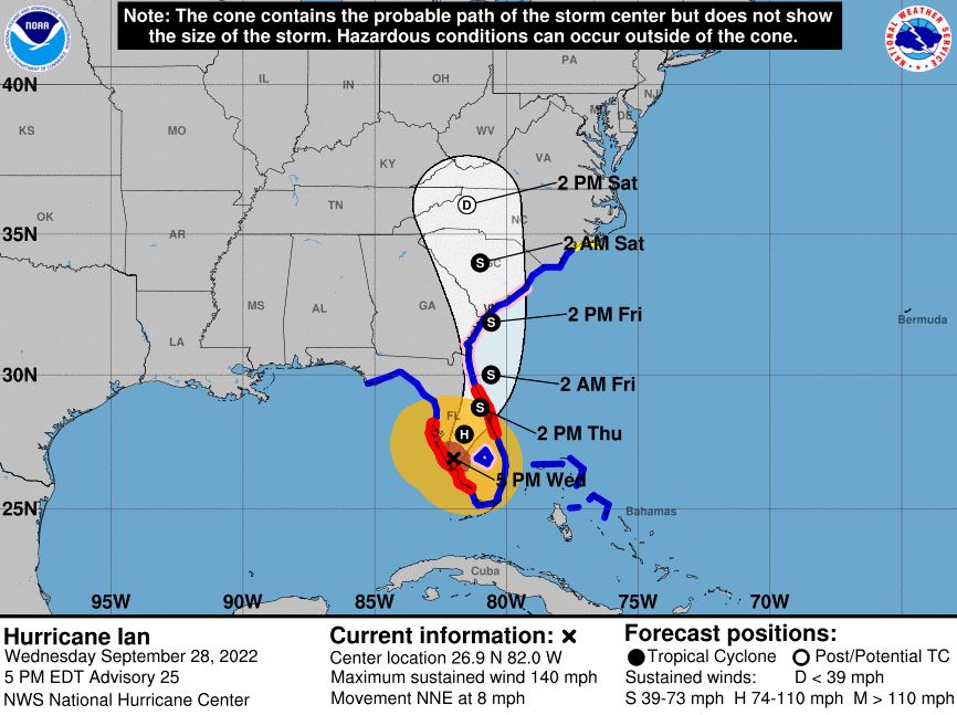
After making landfall in Florida on Wednesday afternoon as a Category 4 storm, Hurricane Ian’s maximum sustained winds have decreased to around 140 mph, and further weakening is expected as the storm moves across central Florida.
As of 5 p.m. on Wednesday, the National Hurricane Center reports that the eye of Ian was located around 5 miles east of Punta Gorda and approximately 120 miles southwest of Orlando. The storm is moving to the north-northeast at a speed of 8 mph.

On the forecast track, the center of Ian is expected to move across central Florida tonight and Thursday morning, emerging over the western Atlantic by late Thursday. Ian is then forecast to turn northward on Friday and approach the northeastern Florida coast, Georgia, and South Carolina coasts late on Friday.
While the NHC anticipates that Ian will weaken over the next day or so, the storm could still be near hurricane strength when it moves over the Florida east coast tomorrow, and when it approaches the northeastern Florida, Georgia, and South Carolina coasts on Friday.
Hurricane-force winds extend outward up to 40 miles from the center, and tropical storm-force winds extend outward up to 175 miles.
According to the NHC, a WeatherFlow station in Grove City recently reported sustained winds of 95 mph and a wind gust of 128 mph. A University of Florida Coastal Monitoring Program wind tower also recently reported sustained winds of 89 mph with a gust of up to 114 mph.
Currently, the NHC predicts that central and northeast Florida may receive anywhere from 12 to 20 inches of rainfall as a result of the storm. Widespread, catastrophic flash, urban, and river flooding is expected to continue across central Florida. Similar flooding is also expected across portions of northeast Florida, southeastern Georgia, and eastern South Carolina later this week through the weekend.
The NHC states that a few tornadoes are possible this evening into tonight across east central Florida.
Due to the approaching storm, the Marion County Sheriff’s Office Division of Emergency Management announced multiple government office and service closures.

